A South Island road trip has long gaps between towns, mountain passes that close in bad weather and campsites that fill up early in summer, so the apps that matter are the ones that tell you what is open, what the weather is doing and where you can sleep. This list covers seven, with official sources for roads and warnings, using prices and ratings from the New Zealand App Store checked on 21 October 2026. KiwiCamping is ours, and it leads as the trip planner; the road and weather information comes from the agencies that publish it.
South Island road trip apps at a glance
Plan the nights and the route in KiwiCamping, check roads on NZTA's Journey Planner and weather on MetService, compare fuel in Gaspy and find a place to stay with CamperMate or Rankers. DOC's alerts page covers closures on conservation land.
The road and weather sources are official websites or agency apps; an app can tell you where a campsite is, but the agencies that run the roads and the weather publish the closures and warnings.
| App or site | Best for | Price | NZ rating |
|---|---|---|---|
| KiwiCamping | A dated trip plan with DOC places | Free to download, with in-app purchases | 3.8 (4) |
| NZTA Journey Planner | Road closures, roadworks and cameras | Free website | Not applicable |
| MetService | Weather warnings and rain radar | Free | 2.4 (1,126) |
| Gaspy | Crowd-sourced fuel prices | Free; optional subscription NZ$1.69 a month | 4.0 (783) |
| CamperMate | Free offline maps and listings | Free; contains ads | 4.4 (606) |
| Rankers Camping NZ | Reviews of welcome overnight spots | Free | 4.7 (3,322) |
| Plan My Walk | Short walks, alerts and trip plans | Free | 4.6 (612) |
1. KiwiCamping: best for planning the nights and the drive
KiwiCamping puts DOC campsites and huts, holiday parks and dump stations on one map, with fees, facilities and rules for each. In its August 2026 data the South Island's DOC regions hold 44 campsites in Marlborough, 37 in Nelson Tasman, 30 in Otago, 22 in Canterbury, 14 on the West Coast, 13 in Fiordland and 5 in Southland, and many more huts.
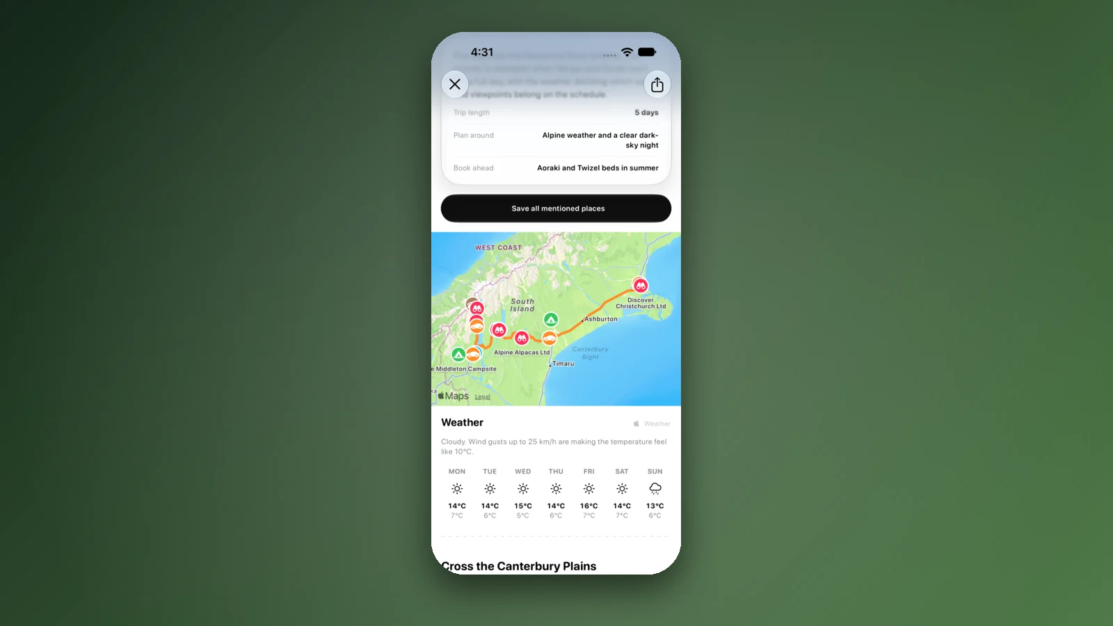
Its road-trip guides include Picton to Christchurch via Kaikōura, Christchurch to Tekapo and Aoraki, Queenstown to Glenorchy and the West Coast, each with a route on the map, a forecast and notes on what to book ahead. You can add stops with dates to a trip and see the drive time between them.
Place details stay on the phone without signal, but map tiles, routing, weather and photos need a connection, so check NZTA for road closures. It is iPhone only (iOS 26 or later) with 4 New Zealand ratings averaging 3.8.
- Choose it for: a dated route with DOC places
- Check NZTA for road closures
- iPhone only; few ratings
2. NZTA Journey Planner: best for road closures and roadworks
NZTA's Journey Planner is a website, not an app, and shows travel times, traffic cameras and updates on delays, roadworks and road closures. NZTA says its route suggestions come from Google, and there may be closures or unplanned events on state highways that make the route shown unsuitable, so check the map before you travel.
For local roads, NZTA tells you to check with the local or regional council. Our guide to one-lane bridges and gravel roads covers the driving side. The separate NZTA Waka Kotahi app is for licences and registration, not live traffic.
- Choose it for: closures and roadworks
- Check the map before you travel
- Website, not an app
3. MetService: best for weather warnings
MetService is New Zealand's official weather service. Its free app shows severe weather warnings and watches, a rain radar and live traffic cameras for urban locations. It rated 2.4 from 1,126 New Zealand ratings, and its website carries the mountain forecasts.
DOC points to MetService for mountain forecasts and says anyone going into the mountains should also check the New Zealand Avalanche Advisory. Our guide to weather apps compares it with the other options.
- Choose it for: official warnings
- Rated 2.4 from 1,126
- Mountain forecasts on its website
4. Gaspy: best for fuel on the long stretches
Gaspy shows crowd-sourced fuel prices and is free, with an optional subscription at NZ$1.69 a month. It rated 4.0 from 783 New Zealand ratings.
On the Milford Road, DOC says there are no shops or fuel stations between Te Anau and Milford Sound, and to have a full tank before leaving Te Anau. A return trip from Te Anau is 240 km, and DOC says an eight-hour day is needed if you plan to take in the sights, short walks and a boat cruise.
- Choose it for: comparing fuel prices
- Full tank at Te Anau
- Crowd-sourced prices
5. CamperMate: best free all-rounder with offline maps
CamperMate is free and covers New Zealand and Australia, with campsites, holiday parks, dump stations, toilets and Wi-Fi, and its listing says you can download maps and use it without an internet connection. It rated 4.4 from 606 New Zealand ratings and shows ads.
On long stretches such as the West Coast, downloaded maps matter more than live data, so download the region before you leave town.
- Choose it for: maps without signal
- Contains ads
- Download before the long stretches
6. Rankers Camping NZ: best for reviews of welcome overnight spots
Rankers is free, and its 3,322 New Zealand ratings average 4.7. It lists places where the local community has said overnight stays are welcome, with traveller reviews that its team reads, and its campsite information works offline from the start.
Detailed maps are a download, so get them over Wi-Fi first, and it lists fewer places than WikiCamps.
- Choose it for: vetted overnight spots
- Free
- Fewer places
7. Plan My Walk: best for short walks and sharing your plan
Plan My Walk is the Mountain Safety Council's free app, with alerts from DOC and local councils, forecasts from MetService and a trip planner that sends your plan to an emergency contact. It rated 4.6 from 612 New Zealand ratings.
It works offline with an eligible satellite plan, and without one you download a PDF of your trip plan first.
- Choose it for: walks and trip plans
- Free
- Offline needs a satellite plan or PDF
The Milford Road and the mountain passes
DOC says the Milford Road has public toilets only at Te Anau, Knob's Flat and Milford, that snow chains may be required and can be rented in Te Anau, and that drivers should check the status of State Highway 94. The section between the Hollyford Road junction and The Chasm is a Restricted No Stopping Zone because it is an avalanche area, and DOC says to take a bus if you are not confident driving in winter conditions.
DOC adds that dogs are not allowed in the national park. Check road status before you leave and again at your last town.
- Chains may be required
- No stopping in the avalanche zone
- Check SH94 status
How we chose and checked
We picked the tools a South Island driver uses for the trip plan, roads, weather, fuel and places to stay, and checked their price, rating and features on the New Zealand App Store on 21 October 2026. Road, weather and Milford Road information comes from NZTA, MetService and DOC.
Warnings and conditions change by the hour, so use these tools to plan and the agencies to decide. If an app has a feature we do not mention, that is an omission, not a claim.
สถานที่ตลอดทาง
ตรวจสอบก่อนออกเดินทาง
กฎและเงื่อนไขเปลี่ยนได้ ตรวจสอบแหล่งข้อมูลทางการและหน้าของอุทยานหรือแคมป์ไซต์ที่คุณจะไปอีกครั้งก่อนออกเดินทาง
คำถามที่พบบ่อย
What apps do I need for a South Island road trip?+
A trip planner such as KiwiCamping, NZTA's Journey Planner for road closures, MetService for weather warnings, Gaspy for fuel and a camping app such as CamperMate or Rankers for places to stay.
Is there fuel on the Milford Road?+
DOC says there are no shops or fuel stations between Te Anau and Milford Sound, and to have a full tank before leaving Te Anau. A return trip from Te Anau is 240 km.
How do I check if a South Island road is closed?+
Use NZTA's Journey Planner, which shows road closures, roadworks and traffic cameras. NZTA notes its route suggestions come from Google and may not reflect unplanned events on state highways.
Do I need snow chains on the Milford Road?+
DOC says snow chains may be required and can be rented in Te Anau. Check the current status of State Highway 94 before you leave.
พกไปบนถนน
บันทึกจุดแวะ วางแผนทั้งทริป
สร้างเส้นทางเรียงลำดับจากสถานที่ที่บันทึกไว้ คำนวณระยะทาง และเก็บวันที่ บันทึก และสิ่งที่ต้องทำไว้ด้วยกัน